New supply
Updates for walking guide book.
The book, 34 Walks in East Crete
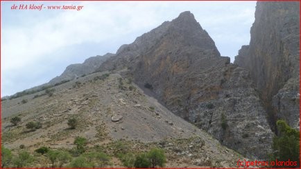
View at the Ha Gorge.
Updated are.
The walks metioned under this line are changed.
Chapter 2. The Ha Gorge.

The sign on the road FARAGGI XA - HA GORGE after the car check garage is loos. Turn right if you find this sign. The words HA GORGE are almost unreadeble because of the sun and sea influenze.
The coffea is only during afternoon and evening to find in this mountainvillage Monasteraki. These two taveernes are closed untill midday.
Blue spots follow this routes nowadays.
This track is along al the way marked with blue dots.
Chapter 3. The Church ruin route.
The route is all the way marked with blue dots.
Chapter 6. The Azoria Gorge.
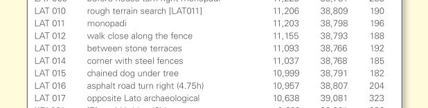
There are now E4 signs and yellow dots on the route.
Chapter 8. The Hondras Wine plantations.
The route is now marked with blue dots.
Chapter 9. The Havga Gorge.
We have extra coördinates because the area was flooded and reorganized.
Schedule additional observations regarding gps plowed land and high water. At 279 waypointnumber the double dot we walk at to the left upwards. Here is a new waypoint. The new point is 506 beyond the double dot we go left uphill on the coordinates N 35 4.194 and E 25 38.939 at 623 meters altitude.
At number 282 you have a choice. Or you walk up with the entrance of the path to the top. The elapsed time is now 1 hour and 15 minutes. Or you walk uphill to number 283 the to the small church on the edge. Elapsed time. 1 hour and 30 minutes.
If you are back down again. Or you choose to stay down you continue to point 284. Now we walk to the large wild Cypressetree. Here you turn right the olive grove in. Here is a new waypoint. At waypoint number 507 you leave here the olive grove and go into the valley. The coordinates are N 35 4.175 and E 38.671 25 at an altitude of 692 meters.
Chapter 10. The Gorge bij Kavoussi.
10 Avgo gorge. The route is now marked with blue and yellow dots.
Chapter 16. The Amiras highland.
This route is temporarily partially blocked. About one kilometer before waypoint GPS005 there are beehives. This road is only passable with a closed Jeep 4 x 4. Danger. Bees. On the link below, we offer you an alternative walking tour.
Chapter 16 alternative. The Omalos plateau.
The Omalos plateau near Kato Simi
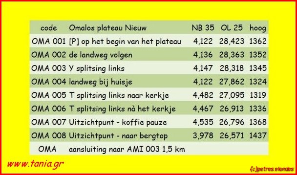
- OMA 001 P Start on the plateau
- OMA 002 follow countryroad
- OMA 003 Y spilt turn left
- OMA 004 countryroad pass the house
- OMA 005 T split turn left direction of the church
- OMA 006 T split turn left after the church
- OMA 007 Panorama Coffea Frappee have a break
- OMA 008 continue upwards
- possibility to connect the Amiras roundwalk. To AMI 003 1,5 Kilometer
- OMA 008 or turn around and go back to the start
Chapter 17. The Kavoussi Rondwandeling.
Partly new yellow dots and E4 signs.
Chapter 18a en 18b. The Lato Gorge Kritsa.
Near the village Tapas are extra coordinates.
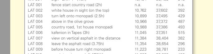
These codes are important because we do not have existing trails.
Chapter 19. The forest near Tripti.
E4 signs are being placed.
Chapter 21. Three gorges walk in the mountains noth of Pefki.
This route is gemarked with blue dots.
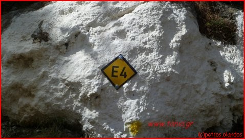
Chapter 26b. The GPS Exo Mouliana Richtiskloof.
New blue dots at the ruin. See picture.
The overgrown area we will now avoid. The wooden bridge has been removed because of rotten wood. This walk I have walked again. Waypoint 291 is at the overgrown ruin. Here is the wooden bridge removed. Via stones we cross the little river. The exit out of the gorge is completely overgrown with blackberries and other shrubs.
Waypoint 292. Here we have a new path created and marked. The exit is now plain to see. Left in the roadside you see blue dots. Follow the dots to the country road on top. Waypoint 292 exit after the wall left has expired. Waypoint up 293 blackberries has expired. The coordinates are now replaced by a new waypoint 508 to exit after wall on the left side.
GPS 508 N 35° 10.747' and E 25° 59.257' on 194 meters altitude. At the waypoint 301 is a very narrow climbing path. This is on the upper terrace with only one olive tree on it. At the beginning of this path we made also blue dots. Follow the dots to top and find the country road.
New extra waypoint.
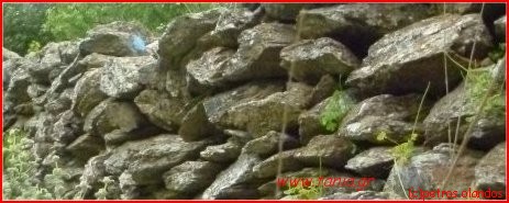
And a new blue dot after the ruin, to exit the gorge. On this wall of stones. See picture top left.
New walk. Beaches and the city center of Ierapetra
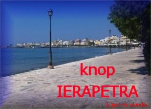
Picture is link to Ierapetra.
Rolf in action.


East Crete
Guidebook